Browse crosses
![]()
![]()
![]()

|
Browse crosses |
|
 Location:
From Teigncombe Farm, take
the road back towards Chagford, go around a right hand bend and the socket
stone is in the field facing you on the next bend in the road, about 200
yards from the farm. Alternatively, walk up North Hill Lane from Leigh
Bridge towards Teigncombe Farm, turn right onto the narrow road, from
Chagford, at the top and the stone is to be found in the field to your left
on the first bend you reach in the road. Location:
From Teigncombe Farm, take
the road back towards Chagford, go around a right hand bend and the socket
stone is in the field facing you on the next bend in the road, about 200
yards from the farm. Alternatively, walk up North Hill Lane from Leigh
Bridge towards Teigncombe Farm, turn right onto the narrow road, from
Chagford, at the top and the stone is to be found in the field to your left
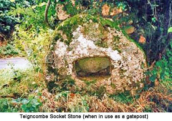
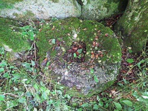
on the first bend you reach in the road.O/S Grid Ref: SX/67378/87158 Longitude/Latitude (Degrees+/-): -3.87807/50.66893 Map location: Click here to view map. Purpose: Although now abandoned in a field, this socket stone would originally have been used to support a waymarker cross. This would probably have marked the route of the Mariner’s Way, which passes through Teigncombe Farm. More information on this ancient track can be found on our page for Leeper Cross, which is also sited on this route. Size: The circular socket stone is 3 feet 9 inches (1.14 metres) in diameter and 12 inches (0.30 metres) deep. The rectangular socket in centre of the stone measures 16 inches (0.41 metres) by 10 inches (0.25 metres) and goes right the way through the stone.. Information: For many years this stone was set vertically in the ground and used as a roadside gatepost for the apse end of the gate. However, a visit in 2021 revealed that the stone has now been replaced by a round wooden gatepost. The socket stone now lies abandoned in the field, around to the left, and is lying flat on the ground under an overhanging tree and covered in undergrowth. (I managed to clear most of the undergrowth in order to take the photo opposite).
It is unusual, but not unique, in Dartmoor socket stones for the hole to go right the through the stone. Other examples of this are the socket stones for the Cadover and Whitchurch Down Crosses. A lady that I spoke to near the site of this stone, during my first visit, informed me that it is referred to locally as a mill-stone. This sets me wondering whether this was its original purpose and that it was later converted to a socket stone and, more recently, to a gatepost. A square hole in the centre of a mill-stone could easily be made larger to accept the shaft of a cross and this could explain the reason for the hole going right the way through the stone. |